Saturday: July 31st
The plan for the day was going to be the long drive home. So we
decided to sleep late and then just go for a short hike at Johnston
Canyon right off Bow valley parkway. But when we got to the trailhead
I just realized that I had left my tripod on the hotel parking lot.
We called up the hotel and fortunately they had the tripod. So we
drove back to the hotel from the trailhead and picked it up. By then
it was too late to go hiking and we started our long drive home. The
drive back was uneventful. We started at around 12:30PM from Banff
and was back in Seattle by 11:30PM including a break in Spokane.
Showing posts with label Travel. Show all posts
Showing posts with label Travel. Show all posts
Friday, August 27, 2010
Canadian Rockies Trip: Day 8 (Yoho National Park)
Friday: July 30th
I woke up at sunrise to go shoot the alpenglow on Mt Lawrence Grassi
which is right next to Canmore. The light was beautiful that morning
and I got some interesting pictures.
The plan for the day was to go to Yoho national park, see some of the
sights and then do a hike there. We had heard a lot about the iceline
trail and we were hoping to do it.
Spiral Tunnels: The Canadian pacific railways routes their trains
through Kicking horse pass in Yoho national park. Since the grade on
the pass is very steep and trains can not really do switchbacks the
railway has built a pair of spiral tunnels which are like spiral ramps
that you see in parking lots except that the tunnels are built into
the mountain side. We saw the tunnels from Highway 1, but did not get
to see trains taking the tunnel.
Takakkaw Falls: This is one of the highest waterfalls in Canada and is
a beautifu sight from below. Unfortunately for us, it began to rain
once we were at the falls. We decided to cancel our hiking plans and
instead move don to see the Emerald Lake.
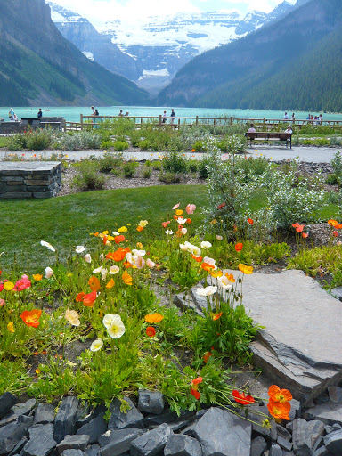
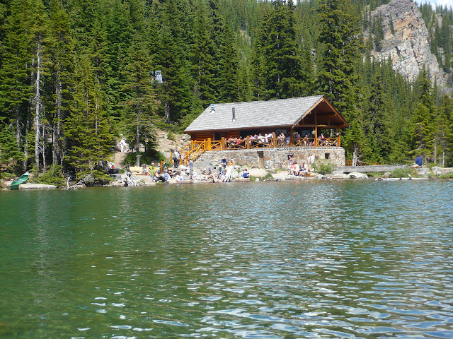
Emerald Lake lived up to its name in its color. It is a beautiful
lake with a lot of similarity to the Maligne lake in that there are
boat houses and resorts on its shore including a restaurant named Cilantro.
From the shore of the lake you can look up to the Burgess Shale quarry which
is a world famous fossil site. Since reading Stephen Jay Gould's book 'Wonderful Life'
about the Burgess Shale fossils, I had always wanted to go and see the
quarry. But on this visit, we did not make the guided trip to the
quarry; nevertheless the names of the landmarks in Yoho reminded me of
the famous fossils (Opabinia, Yohoia, Odaraia, Wiwaxia etc.) from the
shale.
We returned from Yoho and then spent some time in Banff townsite.
Banff is a pretty town which has been heavily commercialized. The
main street through Banff (Banff Ave) is a great place to people watch
and just hang out. Afterwards we went out to Vermilion lakes to
photograph the sunset. The sunset was very pretty and a few other
people joined us there as well.
I woke up at sunrise to go shoot the alpenglow on Mt Lawrence Grassi
which is right next to Canmore. The light was beautiful that morning
and I got some interesting pictures.
The plan for the day was to go to Yoho national park, see some of the
sights and then do a hike there. We had heard a lot about the iceline
trail and we were hoping to do it.
Spiral Tunnels: The Canadian pacific railways routes their trains
through Kicking horse pass in Yoho national park. Since the grade on
the pass is very steep and trains can not really do switchbacks the
railway has built a pair of spiral tunnels which are like spiral ramps
that you see in parking lots except that the tunnels are built into
the mountain side. We saw the tunnels from Highway 1, but did not get
to see trains taking the tunnel.
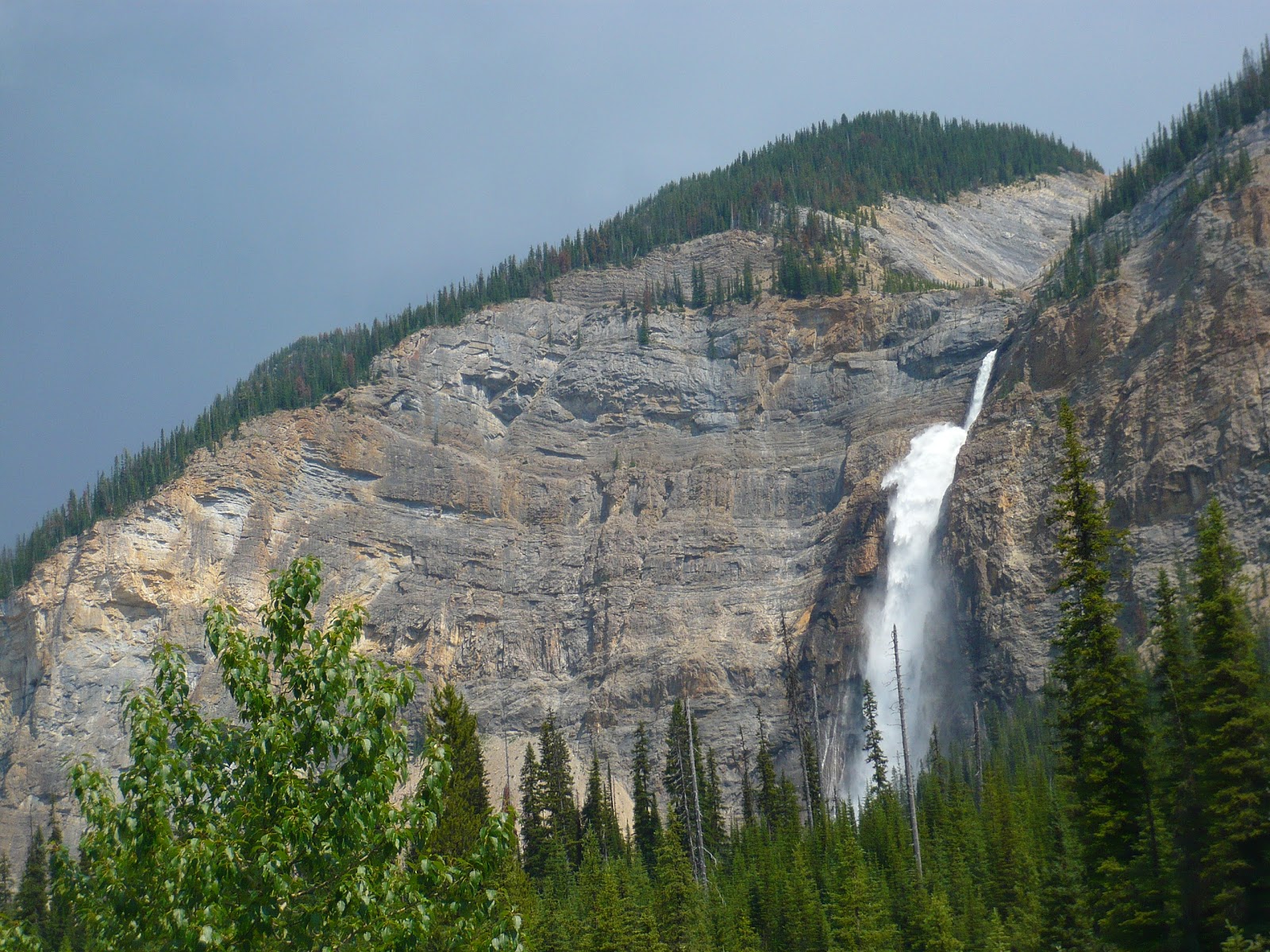 |
| Takakkaw Falls |
Takakkaw Falls: This is one of the highest waterfalls in Canada and is
a beautifu sight from below. Unfortunately for us, it began to rain
once we were at the falls. We decided to cancel our hiking plans and
instead move don to see the Emerald Lake.
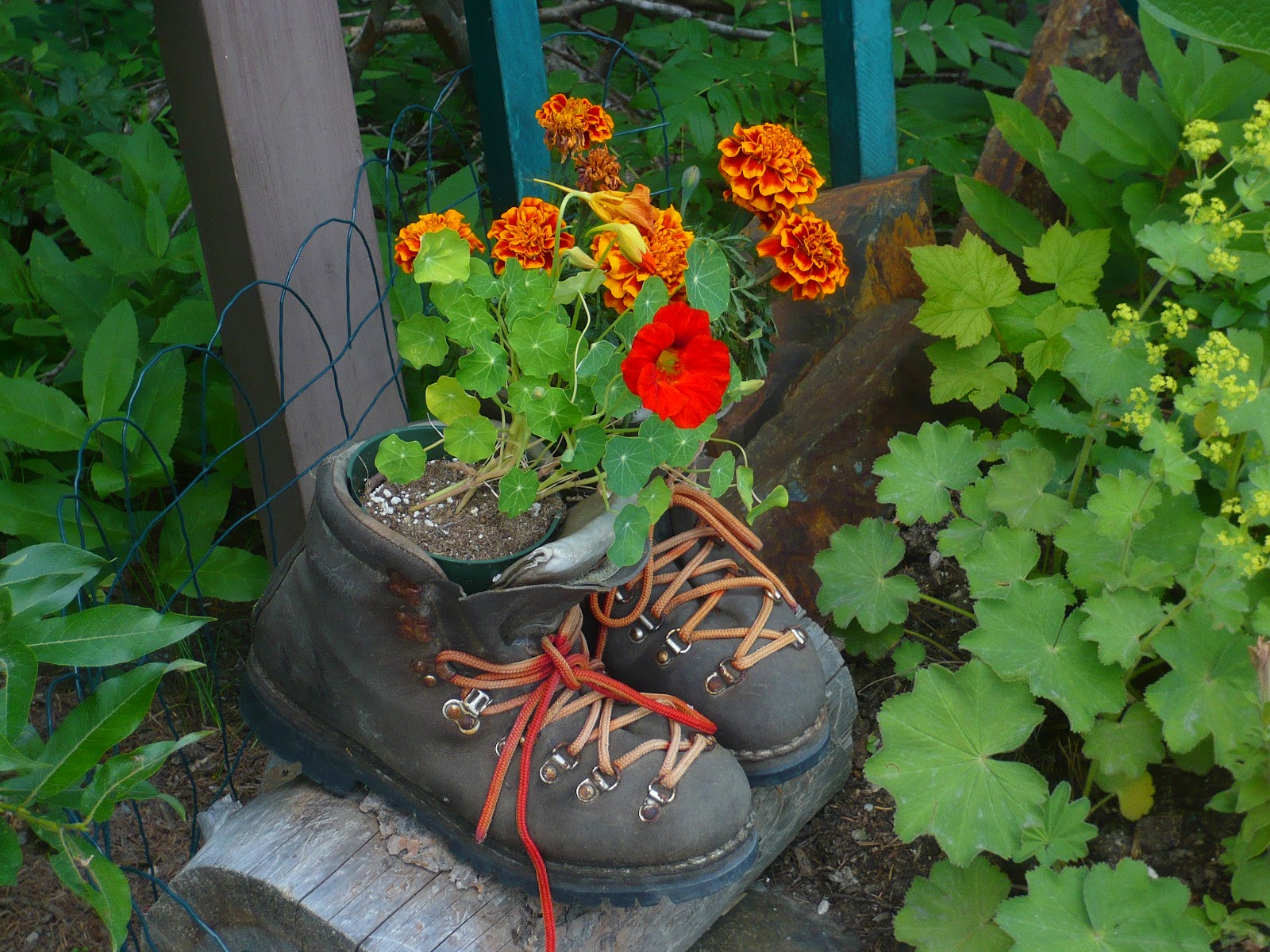 |
| Flower Pot Next to Emerald Lake |
Emerald Lake lived up to its name in its color. It is a beautiful
lake with a lot of similarity to the Maligne lake in that there are
boat houses and resorts on its shore including a restaurant named Cilantro.
From the shore of the lake you can look up to the Burgess Shale quarry which
is a world famous fossil site. Since reading Stephen Jay Gould's book 'Wonderful Life'
about the Burgess Shale fossils, I had always wanted to go and see the
quarry. But on this visit, we did not make the guided trip to the
quarry; nevertheless the names of the landmarks in Yoho reminded me of
the famous fossils (Opabinia, Yohoia, Odaraia, Wiwaxia etc.) from the
shale.
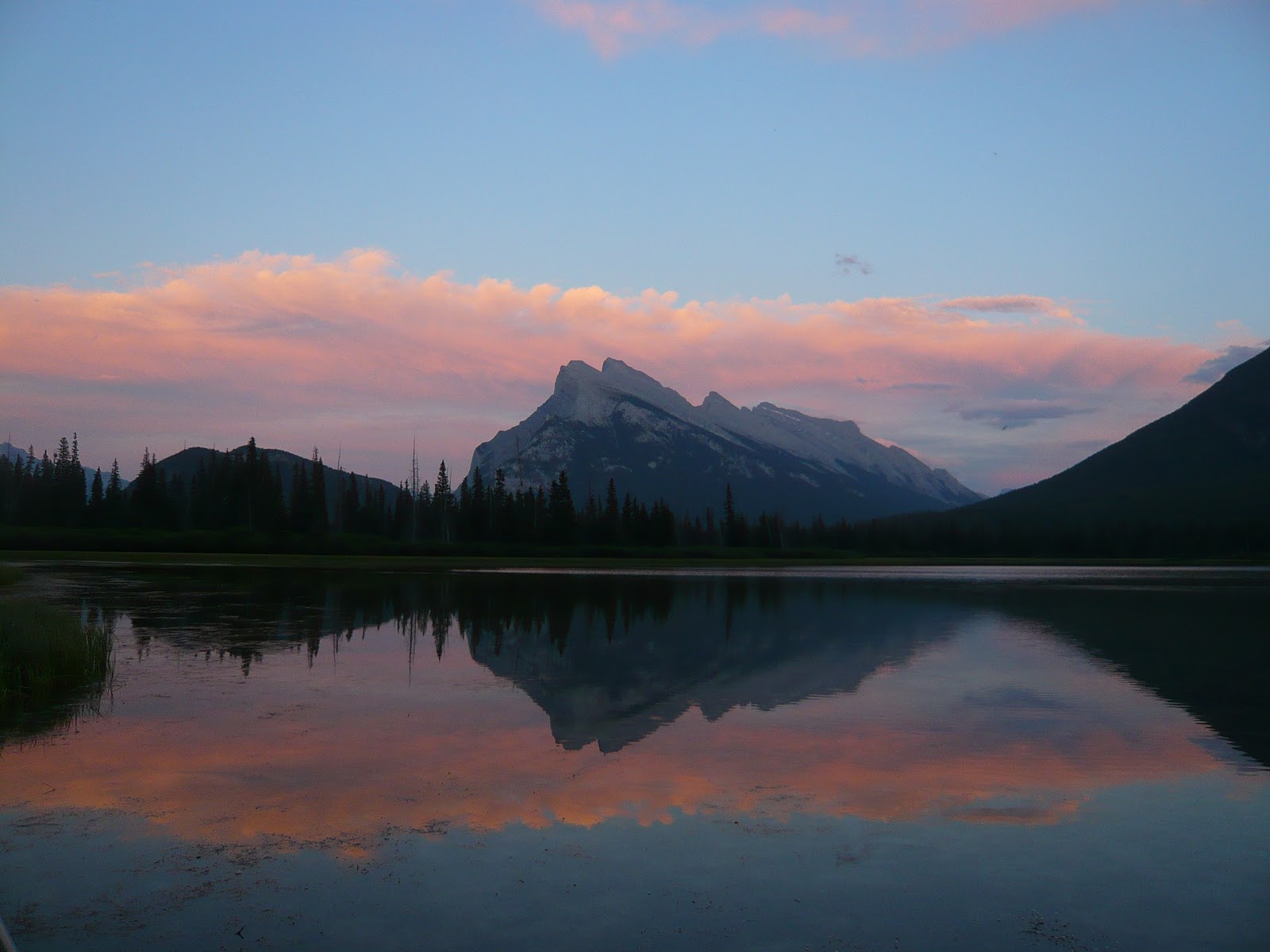 |
| Mt Rundle and Vermilion Lake at Sunset |
Banff is a pretty town which has been heavily commercialized. The
main street through Banff (Banff Ave) is a great place to people watch
and just hang out. Afterwards we went out to Vermilion lakes to
photograph the sunset. The sunset was very pretty and a few other
people joined us there as well.
Canadian Rockies Trip: Day 7 (Icefields Parkway and Parker Ridge)
TravelThursday: July 29th
I woke up early in the morning to shoot the alpenglow on Pyramid peak
reflected on Pyramid lake. Unfortunately a bunch of clouds contrived
to strategically place themselves on the eastern horizon so that the
expected light on Pyramid peak never materialized.
The day's program was to take the Icefields parkway back to Banff and
along the way visit the sights that we missed and also do a hike on
the way.
Sunwapta Falls: The falls were not that remarkable. The Sunwapta
river has excavated a narrow canyon reminiscent of the marble and
Maligne canyons.
Quartzite Boulder Pile: This is a rather non-descript point on the
Icefields parkway where a jumble of multicolored quartzite boulders
are located on both sides of the road. It is a good place to
photograph colorful rock and lichens and we spent some time
photographing there.
Parker Ridge: We wanted to do a hike near the Columbia icefield and
the choices were Wilcox pass or Parker ridge. We settled on the later
since it was shorter and would afford a view to the Saskatchewan
glacier which is not visible from the road. The trail gains 25m
elevation with 2.5km one way distance. It is a very very popular
trail with lots of people on it. The trail starts climbing in a
forest and very soon leaves the treeline behind. As we went up, we
had a beautiful view of the surrounding mountains and the beautiful
Icefields parkway snaking through them. Once at the top, the trail
flattens out and follows the ridge. Aftre following the ridge for a
little, the view to the west opened up and we could see the huge
Saskatchewan glacier.
When at the top we saw some rocks which had
strange white nodules embedded in them. We dawdled for a while at the
alipne tundra at the top, took some pictures and started coming back.
As we were descending the trail we kept seeing rocks with embedded
white nodules. Finally we stopped by one such large rock and looked
closely at it and realized that the white nodules were fossils! It
seems that the trail is littered with fossil-bearing rocks all around.
That evening we reached Banff and moved into the Banff Boundary Lodge
in Harvie Heights right next to the park boundary. We were given a
two bedroom, 1.5 bath condo where we could stretch ourselves out
luxuriously.
I woke up early in the morning to shoot the alpenglow on Pyramid peak
reflected on Pyramid lake. Unfortunately a bunch of clouds contrived
to strategically place themselves on the eastern horizon so that the
expected light on Pyramid peak never materialized.
The day's program was to take the Icefields parkway back to Banff and
along the way visit the sights that we missed and also do a hike on
the way.
Sunwapta Falls: The falls were not that remarkable. The Sunwapta
river has excavated a narrow canyon reminiscent of the marble and
Maligne canyons.
Quartzite Boulder Pile: This is a rather non-descript point on the
Icefields parkway where a jumble of multicolored quartzite boulders
are located on both sides of the road. It is a good place to
photograph colorful rock and lichens and we spent some time
photographing there.
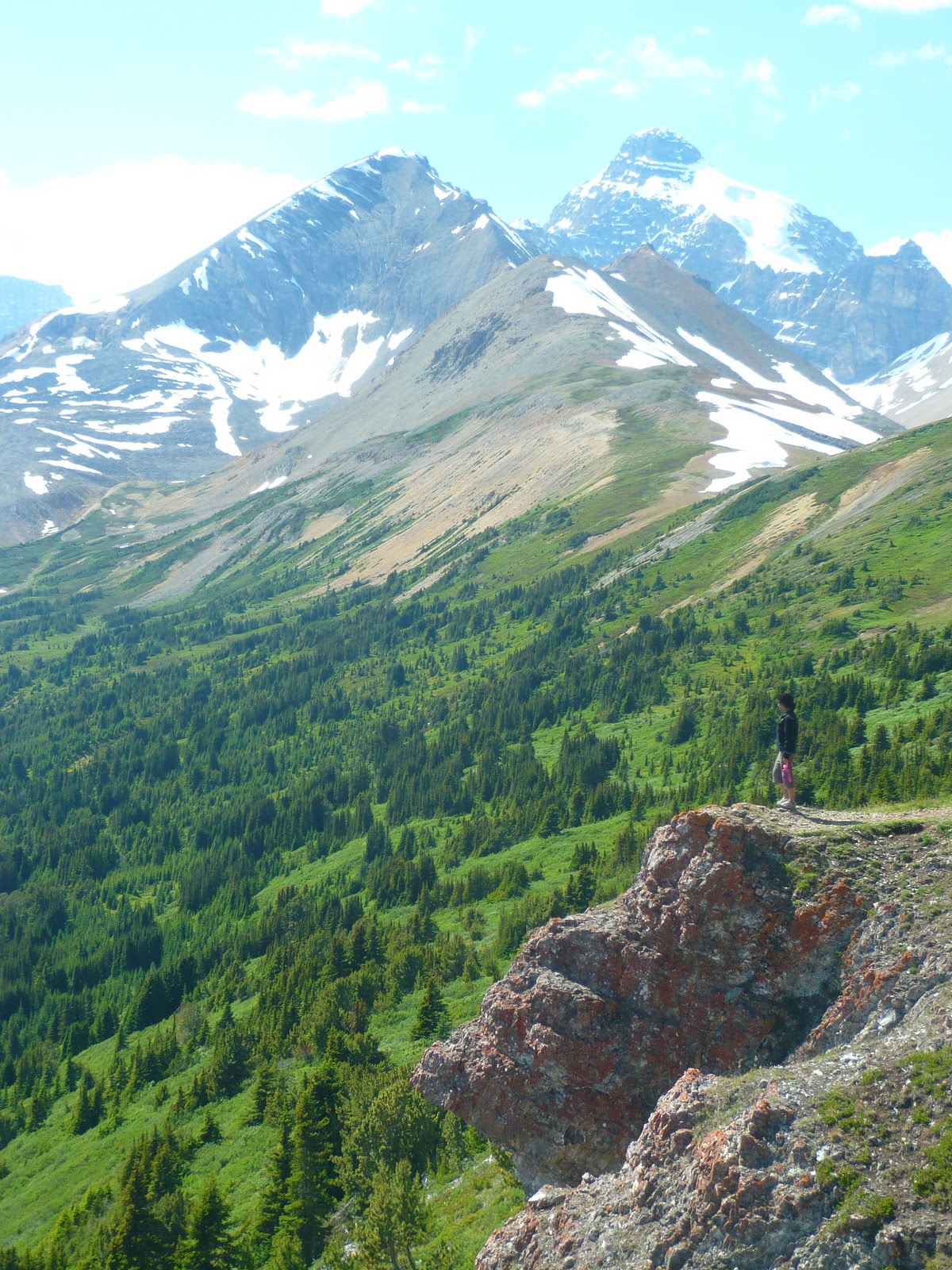 |
| View from Parker Ridge |
Parker Ridge: We wanted to do a hike near the Columbia icefield and
the choices were Wilcox pass or Parker ridge. We settled on the later
since it was shorter and would afford a view to the Saskatchewan
glacier which is not visible from the road. The trail gains 25m
elevation with 2.5km one way distance. It is a very very popular
trail with lots of people on it. The trail starts climbing in a
forest and very soon leaves the treeline behind. As we went up, we
had a beautiful view of the surrounding mountains and the beautiful
Icefields parkway snaking through them. Once at the top, the trail
flattens out and follows the ridge. Aftre following the ridge for a
little, the view to the west opened up and we could see the huge
Saskatchewan glacier.
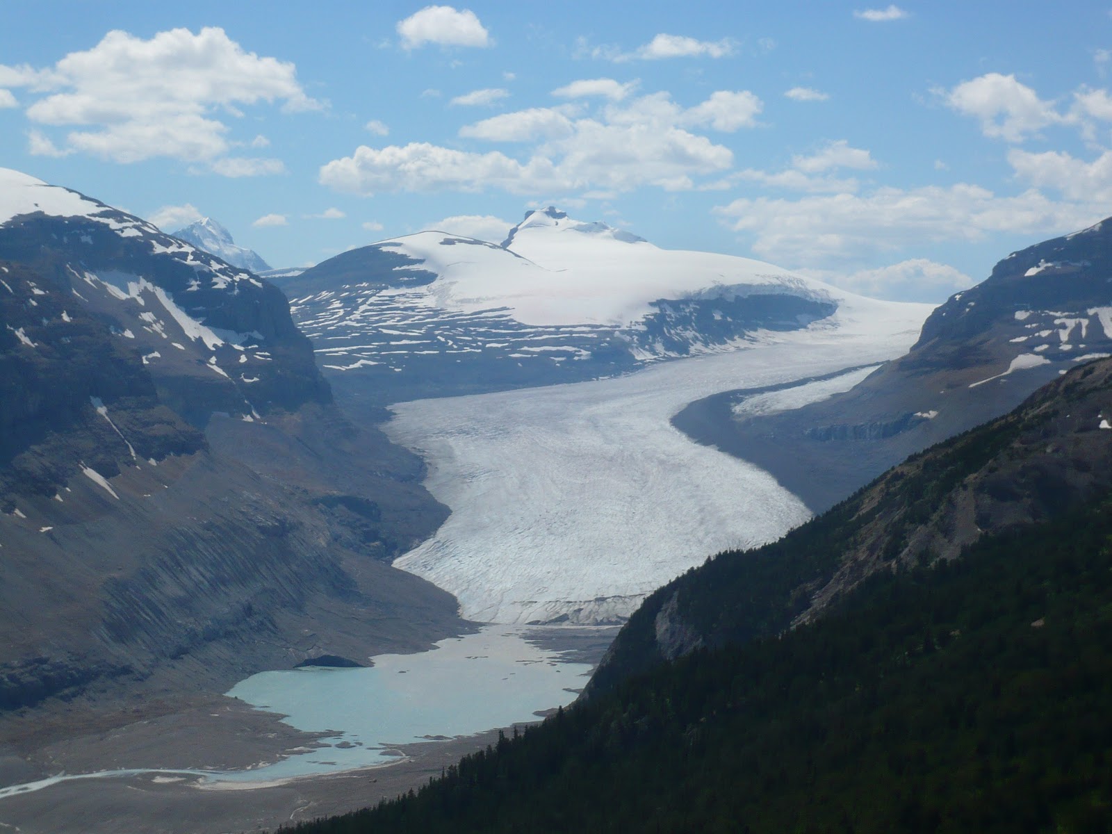 |
| Saskatchewan Glacier |
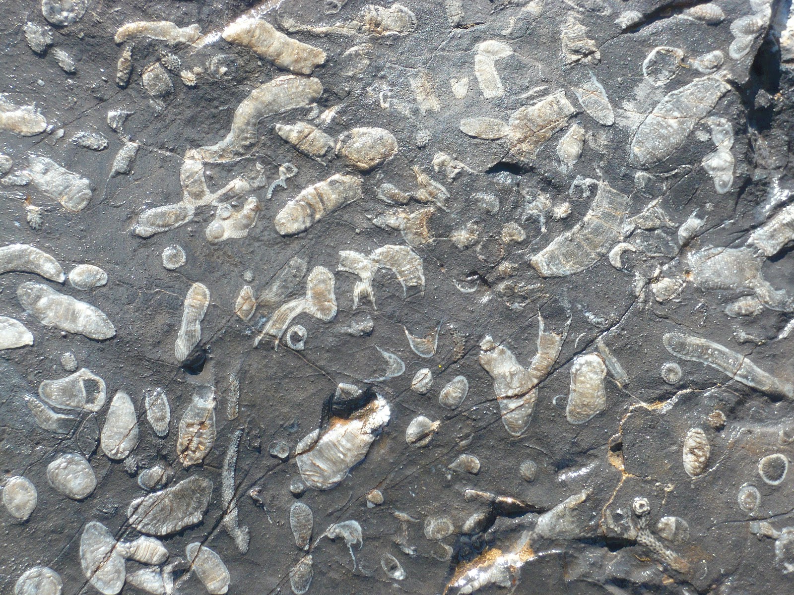 |
| Fossils Embedded in Rock |
strange white nodules embedded in them. We dawdled for a while at the
alipne tundra at the top, took some pictures and started coming back.
As we were descending the trail we kept seeing rocks with embedded
white nodules. Finally we stopped by one such large rock and looked
closely at it and realized that the white nodules were fossils! It
seems that the trail is littered with fossil-bearing rocks all around.
That evening we reached Banff and moved into the Banff Boundary Lodge
in Harvie Heights right next to the park boundary. We were given a
two bedroom, 1.5 bath condo where we could stretch ourselves out
luxuriously.
Thursday, August 26, 2010
Canadian Rockies Trip: Day 6 (Mt. Edith Cavell and Maligne Lake Road)
TrWednesday: July 28th
It rained in the night. This was becoming a fixture of our camping
trips. As soon as we go camping, the rain gods decide to pour some
libations. Good news was that the rain was light and all it did was
to wet the ground. The morning was cloudy and hence I did not get out
for sunrise either.
Patricia and Pyramid Lakes: These two pretty lakes next to the Jasper
townsite sit at the bottom of Pyramid peak. There are a couple of
pretty resorts next to the shore and the lakes form a peaceful place
to spend time.
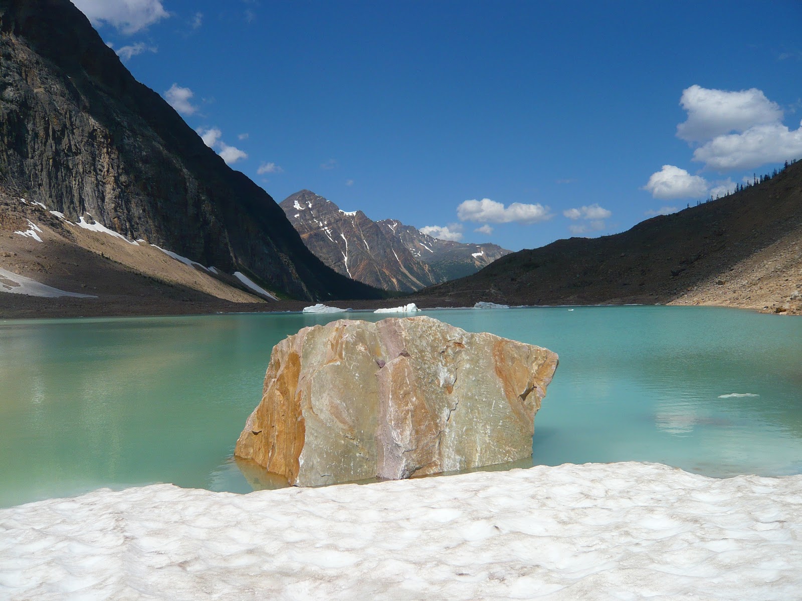
Mount Edith Cavell: Mount Edith Cavell is one of the icons of Jasper,
but it is very hard to photograph. You can drive right to the bottom
of the steep north-east face of the mountain where two glaciers (Angel
and Cavell) tumble down to a glacial lake with chunks of glacial ice
floating on it. When we got there, the late morning sun was not very
conducive to photographing the mountain itself. Moreover the mountain
was so big that unless you had a 14mm lens, you could never hope to
fill it all in the frame. We took the short trial to the glacial lake
and hiked around it all the way to the Cavell glacier.
Maligne Canyon: Maligne lake is one of the biggest lakes in Jasper and
the road that leads to it is well known for wildlife. Our drive to
Maligne lake started with a sight of a bull elk right next to the road
in Jasper. The first attraction on the road was Maligne canyon which
was very similar to Marble canyon in Kootenay except that it was
deeper.
Medicine Lake: Next up is the Medicine lake which is a deep blue lake
surrounded by bright white mountain sides. Medicine lake is unusual
in that it disappears in winter when waterflow in the Maligne river
slows. The lake bed is porous limestone and the entire river flows
underground when the flow is low. Native Indians thought that this
behavior was associated with evil spirits with "Bad Medicine" which
gives the beautiful lake its name. On the shore of the lake, we saw a
couple of Big Horn sheep.
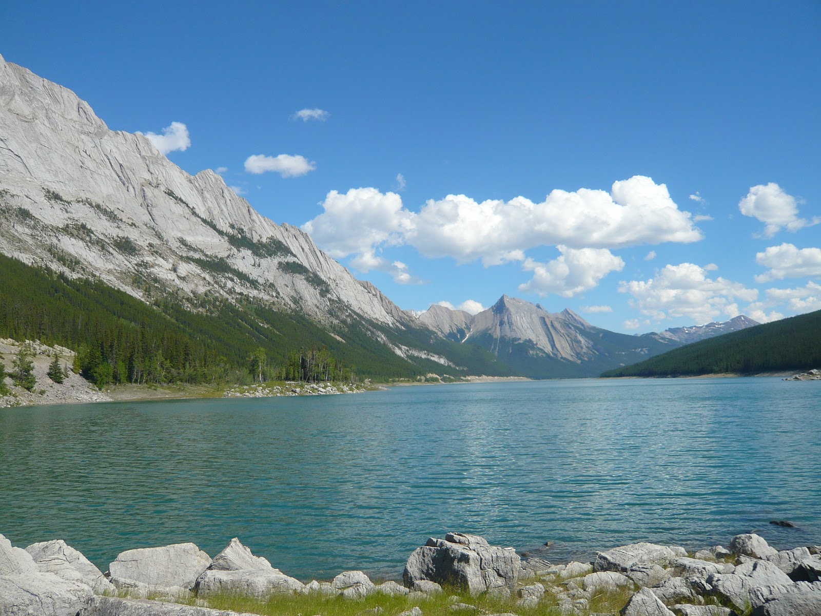
Maligne Lake: This lake is a major tourist attraction, but it did not
inspire me photographically much. Perhaps better light, better
weather was needed.
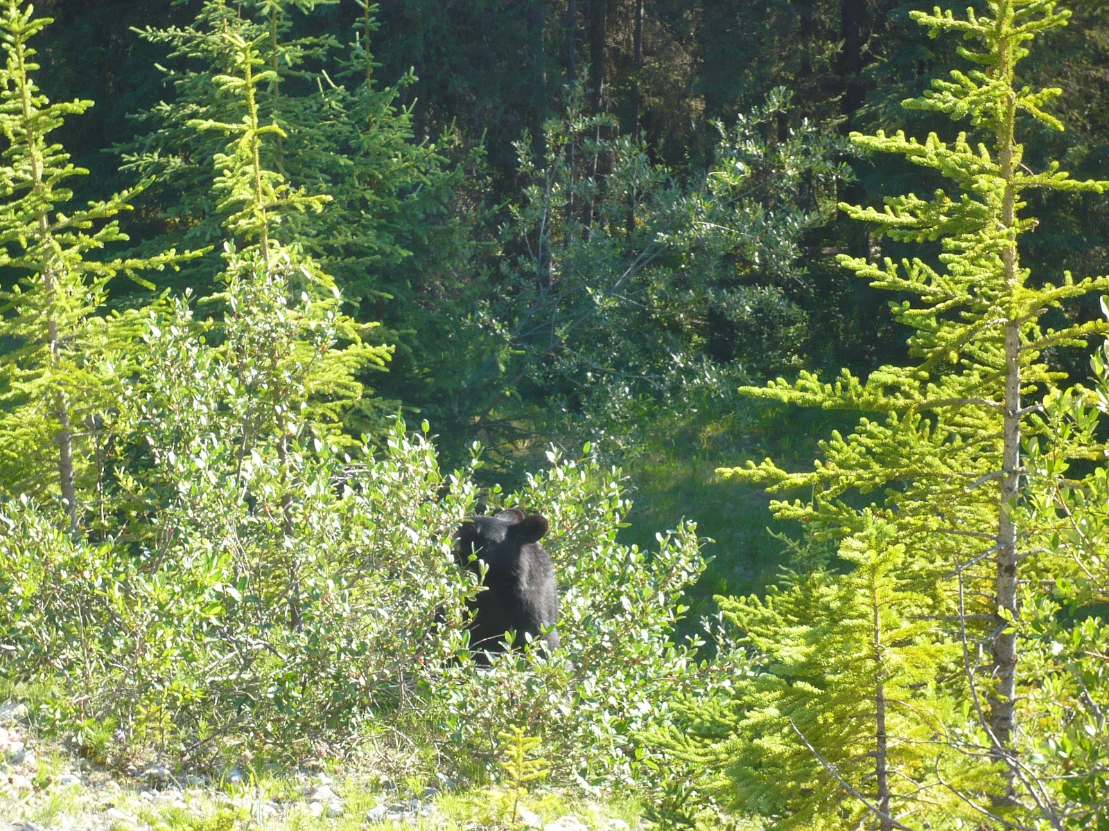
As it was becoming evening, we turned back. On the way back, we saw a
bunch of cars parked next to the road and we pulled over too.
Everybody was frantically taking pictures of a bear which was busy
with a bushful of berries and paying no heed to us gawking tourists.
We aw more wildlife as we drove back: a herd of elks next to Medicine
lake, another bear on the road side and finally more elk near Jasper
townsite.
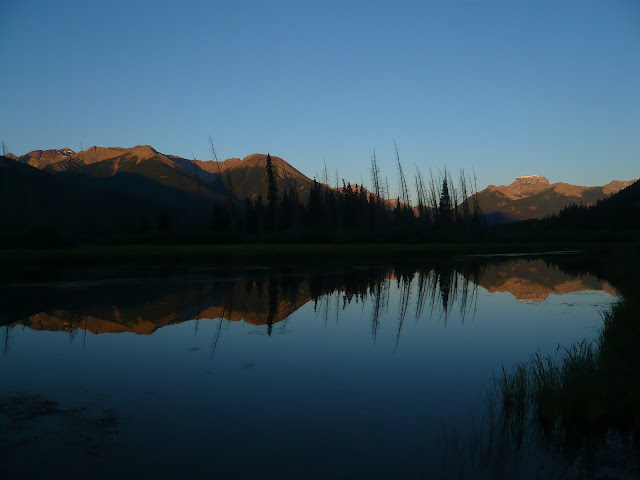
In the evening, we decided to photgraph the evening alpenglow on the
mountains next to Jasper. The light was decent, but not spectacular.
Chiranjeeb
It rained in the night. This was becoming a fixture of our camping
trips. As soon as we go camping, the rain gods decide to pour some
libations. Good news was that the rain was light and all it did was
to wet the ground. The morning was cloudy and hence I did not get out
for sunrise either.
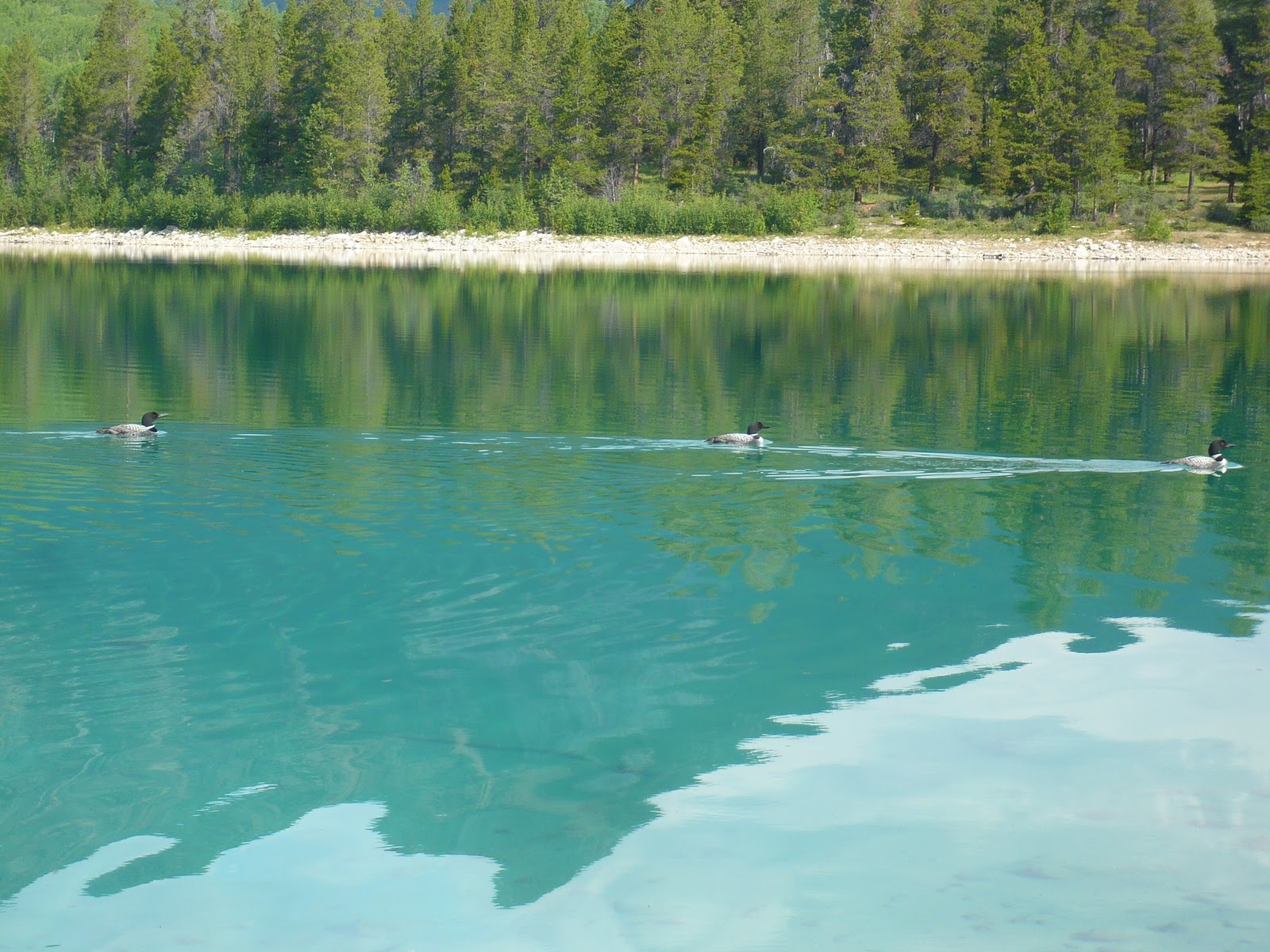 |
| Loons in Patricia Lake |
townsite sit at the bottom of Pyramid peak. There are a couple of
pretty resorts next to the shore and the lakes form a peaceful place
to spend time.
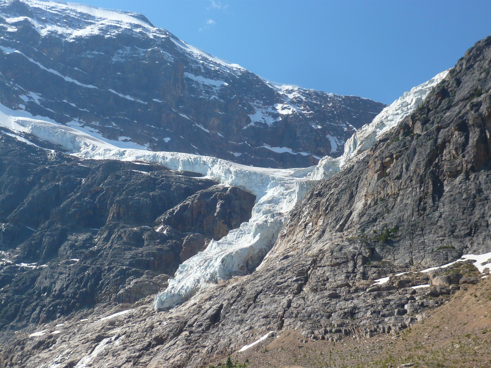 |
| Angel Glacier on Mt Edith Cavell |
 |
| Cavell Pond |
Mount Edith Cavell: Mount Edith Cavell is one of the icons of Jasper,
but it is very hard to photograph. You can drive right to the bottom
of the steep north-east face of the mountain where two glaciers (Angel
and Cavell) tumble down to a glacial lake with chunks of glacial ice
floating on it. When we got there, the late morning sun was not very
conducive to photographing the mountain itself. Moreover the mountain
was so big that unless you had a 14mm lens, you could never hope to
fill it all in the frame. We took the short trial to the glacial lake
and hiked around it all the way to the Cavell glacier.
Maligne Canyon: Maligne lake is one of the biggest lakes in Jasper and
the road that leads to it is well known for wildlife. Our drive to
Maligne lake started with a sight of a bull elk right next to the road
in Jasper. The first attraction on the road was Maligne canyon which
was very similar to Marble canyon in Kootenay except that it was
deeper.
 |
| Medicine Lake |
Medicine Lake: Next up is the Medicine lake which is a deep blue lake
surrounded by bright white mountain sides. Medicine lake is unusual
in that it disappears in winter when waterflow in the Maligne river
slows. The lake bed is porous limestone and the entire river flows
underground when the flow is low. Native Indians thought that this
behavior was associated with evil spirits with "Bad Medicine" which
gives the beautiful lake its name. On the shore of the lake, we saw a
couple of Big Horn sheep.
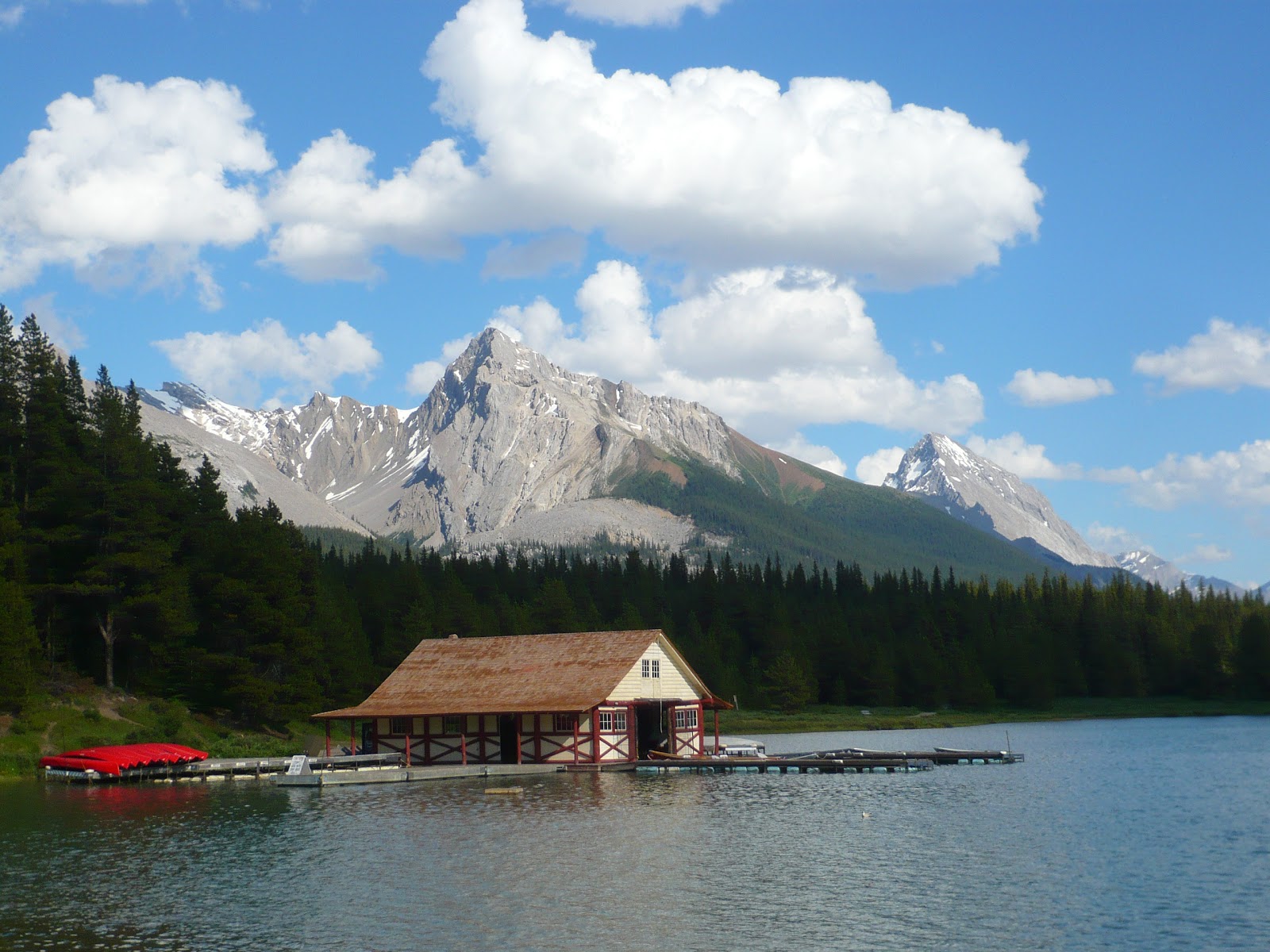 |
| Maligne Lake Boathouse |
Maligne Lake: This lake is a major tourist attraction, but it did not
inspire me photographically much. Perhaps better light, better
weather was needed.
 |
| Bear on Maligne Lake Road |
As it was becoming evening, we turned back. On the way back, we saw a
bunch of cars parked next to the road and we pulled over too.
Everybody was frantically taking pictures of a bear which was busy
with a bushful of berries and paying no heed to us gawking tourists.
We aw more wildlife as we drove back: a herd of elks next to Medicine
lake, another bear on the road side and finally more elk near Jasper
townsite.
 |
| Mt Edith Cavell At Sunset |
In the evening, we decided to photgraph the evening alpenglow on the
mountains next to Jasper. The light was decent, but not spectacular.
Chiranjeeb
Canadian Rockies Trip: Day 5(Icefields Parkway from Banff to Jasper)
Tuesday: July 27th
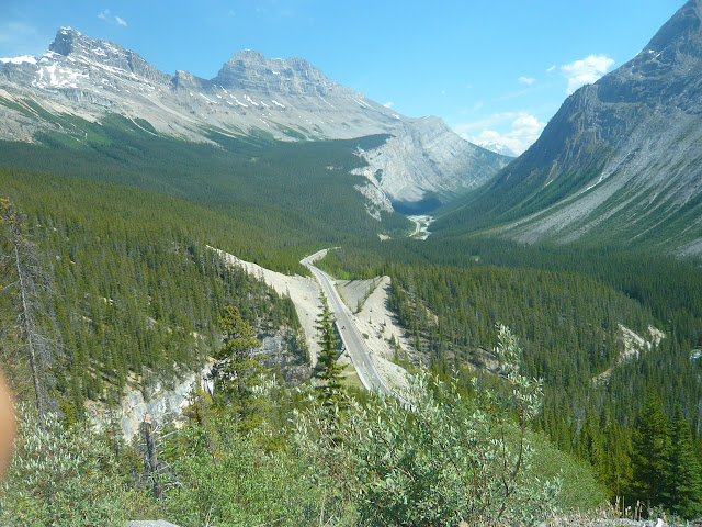
Today's program was to drive the Icefields Parkway to Jasper national
park and camp there for the next two days. The morning was cloudy and
I did not get up for sunrise. The Icefields parkway which stretches
between Lake Louise and Jasper Townsite for 200km is a continuous
visual treat. The Canadian parks boast of it as the most scenic
highway in the world.
Crowfoot Glacier and Bow Lake: Crowfoot glacier is the first glacier
which can be seen close-up from the highway and hence attracts hoards
of tourists. Bow lake is the origin of the Bow river and it sits at
the foot of the Bow glacier. A pretty lodge called Num-Ti-Jah is
located right on the shore.
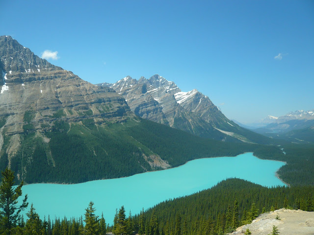
Peyto Lake: Along with Moraine lake this is the iconic lake of the
Canadian Rockies. In midday sun, it looks a gorgeous shade of opaque
green and as a bonus its shape reminds one of a bear's head. A 10 min
trail leads to the viewpoint from the parking lot. The viewpoint was
naturally crowded with tourists and everybody had to take turns in
taking pictures.
Columbia Icefield and Athabasca Glacier: The Icefields parkway goes
over Sunwapta pass and enters Jasper national park. Soon the
Athabasca glacier comes into view whose toe lies very close to the
road. A short trail takes one to within a stone's throw of the
glacier. For safety reasons, the park service prohibits one from
going onto the glacier unless one is with a guided tour.
Goats and Glaciers: The viewpoint is noted for having a salt lick on
it and hence is frequented by herds of mountain goats to get salt.
Hence goats and glaciers.
Athabasca Falls: The Athabasca river starts from the Athabasca glacier
and follows the road to Jasper. The Athabasca falls are not very
high, but the key attraction here is the volume of water on the falls.
Once we reached Jasper, we checked into Wapiti campground. With 364 sites, the Wapiti is a "smaller" campground compared to its neighbor Whistlers which has 781 sites. The Parks Canada campgrounds are positively luxurious with hot showers and poer outlets to charge your cell phone/digital camera. Only downside is their cost and the fact that even to start a fire, you have to pay extra. Our campsite was a nice site right next to that Athabasca river. We cooked dinner and went to sleep early.
Chiranjeeb
Today's program was to drive the Icefields Parkway to Jasper national
park and camp there for the next two days. The morning was cloudy and
I did not get up for sunrise. The Icefields parkway which stretches
between Lake Louise and Jasper Townsite for 200km is a continuous
visual treat. The Canadian parks boast of it as the most scenic
highway in the world.
 |
| Bow Lake and Bow Glacier |
 |
| Icefield Parkway Near Sunwapta Pass |
Crowfoot Glacier and Bow Lake: Crowfoot glacier is the first glacier
which can be seen close-up from the highway and hence attracts hoards
of tourists. Bow lake is the origin of the Bow river and it sits at
the foot of the Bow glacier. A pretty lodge called Num-Ti-Jah is
located right on the shore.
 |
| Peyto Lake |
Canadian Rockies. In midday sun, it looks a gorgeous shade of opaque
green and as a bonus its shape reminds one of a bear's head. A 10 min
trail leads to the viewpoint from the parking lot. The viewpoint was
naturally crowded with tourists and everybody had to take turns in
taking pictures.
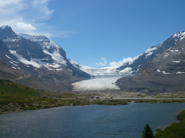 |
| Athabasca Glacier |
over Sunwapta pass and enters Jasper national park. Soon the
Athabasca glacier comes into view whose toe lies very close to the
road. A short trail takes one to within a stone's throw of the
glacier. For safety reasons, the park service prohibits one from
going onto the glacier unless one is with a guided tour.
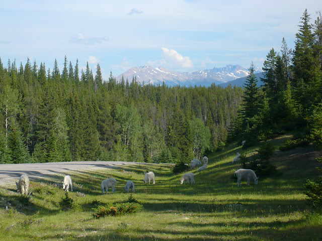 |
| Mountain Goats |
it and hence is frequented by herds of mountain goats to get salt.
Hence goats and glaciers.
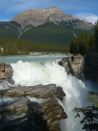 |
| Athabasca Falls |
and follows the road to Jasper. The Athabasca falls are not very
high, but the key attraction here is the volume of water on the falls.
Once we reached Jasper, we checked into Wapiti campground. With 364 sites, the Wapiti is a "smaller" campground compared to its neighbor Whistlers which has 781 sites. The Parks Canada campgrounds are positively luxurious with hot showers and poer outlets to charge your cell phone/digital camera. Only downside is their cost and the fact that even to start a fire, you have to pay extra. Our campsite was a nice site right next to that Athabasca river. We cooked dinner and went to sleep early.
Chiranjeeb
Canadian Rockies Trip: Day 4 (Lake O'Hara at Yoho NP)
Monday: July 26th
We woke up at 4AM and headed out at 5AM to Lake O'Hara parking
lot in Yoho National Park. Lake O'Hara is the most coveted day hiking
destination in the Canadian rockies and they have a quota of 42 day
hikers per day allowed into the area where they are bused in from the
parking lot on an 11km dirt road to Lake O'Hara itself. The 42 places
on the bus can be reserved 3 months in advance and they typically sell
out within an hour of becoming available. So our only hope was that
there would be some cancellations on the day we show up and we can
grab those cancelled spots as standby hikers. We got to the parking
lot at 6AM for the 8:30AM bus. Thankfully, there were enough
cancellations and we were lucky to get on the bus. On the lake shore
we decided to take the Opabin Plateau loop and started the hike around
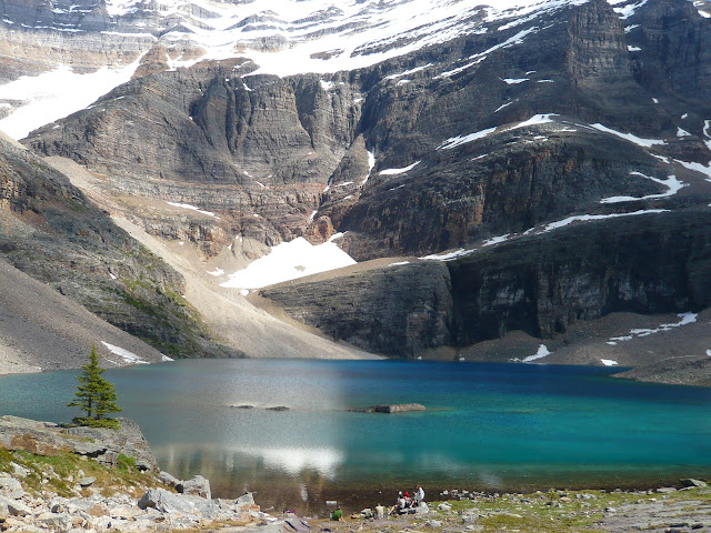
9AM. Highlights of Lake O'Hara:
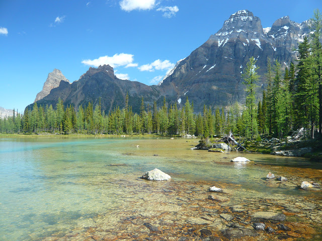
Opabin Plateau: Beautiful view from Opabin prospect down to Lake O'Hara and
Lake Mary. The plateau is dotted with a bunch of small lakes and streams
around which you can wander. There are a lot of Larch trees which turn beautiful yellow in fall.
Yukness Ledges: This trail connects Opabin plateau to lake Oesa. It
is a very narrow trail which precariously hugs the side of a cliff
most of the time and requires some judicious route finding. Not
something for poeple with a fear of heights.
From the trail you get
continuous views of Lake O'Hara and its surrounding peaks. Every
single step of this trail has a beautiful view.
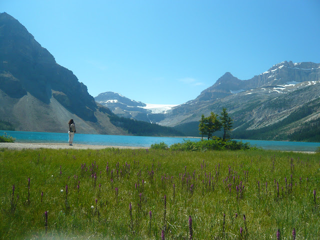
Lake Oesa: Lake Oesa is a large deep blue lake set in a glacial cirque
surrounded with cliffs. Water out of the lake cascades through a
series of waterfalls and more smaller lakes to finally end up on Lake
O'Hara. The trail from Lake Oesa down to Lake O'Hara is very steep
and would not be easy if we tried to come up it.
We came down the lake Oesa trail and took the 4:30PM bus out. Lake
O'Hara is the most beautiful place we have seen and was the highlight
of our trip. This place has hikes to suit every level of fitness and
all of them are equally beautiful. We would wholeheartedly recomend
anybody going there to make an attempt to visit the place. I took a
lot of pictures here: every turn in the trail brings someting more
interesting to see and seem to deserve a picture of its own.
Chiranjeeb
We woke up at 4AM and headed out at 5AM to Lake O'Hara parking
lot in Yoho National Park. Lake O'Hara is the most coveted day hiking
destination in the Canadian rockies and they have a quota of 42 day
hikers per day allowed into the area where they are bused in from the
parking lot on an 11km dirt road to Lake O'Hara itself. The 42 places
on the bus can be reserved 3 months in advance and they typically sell
out within an hour of becoming available. So our only hope was that
there would be some cancellations on the day we show up and we can
grab those cancelled spots as standby hikers. We got to the parking
lot at 6AM for the 8:30AM bus. Thankfully, there were enough
cancellations and we were lucky to get on the bus. On the lake shore
we decided to take the Opabin Plateau loop and started the hike around
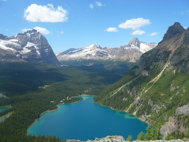
9AM. Highlights of Lake O'Hara:
 |
| Tarn on Opabin Plateau |
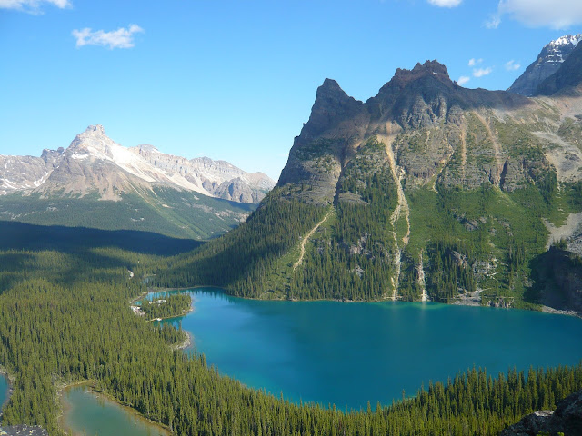 |
| View from Opabin Prospect |
Opabin Plateau: Beautiful view from Opabin prospect down to Lake O'Hara and
Lake Mary. The plateau is dotted with a bunch of small lakes and streams
around which you can wander. There are a lot of Larch trees which turn beautiful yellow in fall.
 |
| Opabin Lake |
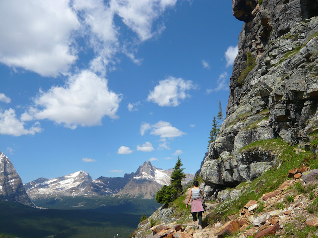 |
| Yukness Ledges Trail |
Yukness Ledges: This trail connects Opabin plateau to lake Oesa. It
is a very narrow trail which precariously hugs the side of a cliff
most of the time and requires some judicious route finding. Not
something for poeple with a fear of heights.
 |
| View from Yukness Ledges Trail |
 |
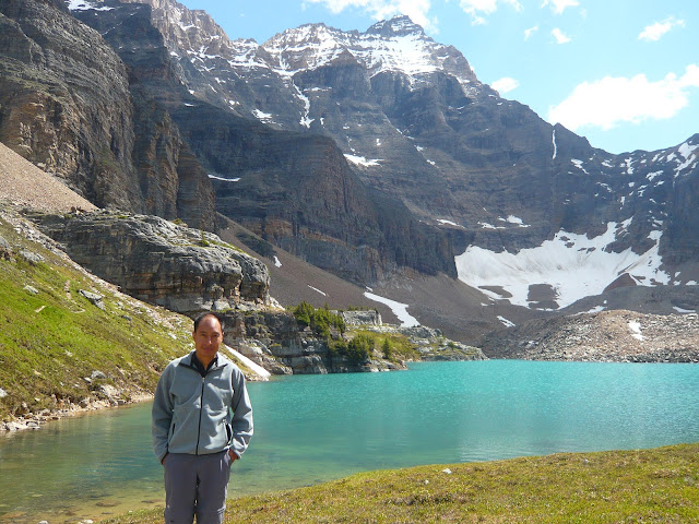
| Lake Oesa |
continuous views of Lake O'Hara and its surrounding peaks. Every
single step of this trail has a beautiful view.
Lake Oesa: Lake Oesa is a large deep blue lake set in a glacial cirque
surrounded with cliffs. Water out of the lake cascades through a
series of waterfalls and more smaller lakes to finally end up on Lake
O'Hara. The trail from Lake Oesa down to Lake O'Hara is very steep
and would not be easy if we tried to come up it.
We came down the lake Oesa trail and took the 4:30PM bus out. Lake
O'Hara is the most beautiful place we have seen and was the highlight
of our trip. This place has hikes to suit every level of fitness and
all of them are equally beautiful. We would wholeheartedly recomend
anybody going there to make an attempt to visit the place. I took a
lot of pictures here: every turn in the trail brings someting more
interesting to see and seem to deserve a picture of its own.
Chiranjeeb
Canadian Rockies Trip: Day 3 (Banff and Lake Louise)
Sunday: July 25th
I woke up before sunrise to go and photograph morning light on
Mt Rundle from the Vermilion lakes just outside Banff townsite.
Unfortunately, the morning light was not very good on Mt Rundle, and I
got some more interesting pictures at Two Jack Lake instead.
Moraine Lake: We started our day by driving into Moraine Lake. It is
one of the most beautiful lakes in the Rockies with intense blue water
and beautiful valley of the Ten Peaks rising behind it. There were
beautiful red canoes paddling on the lake which added more contrast to
the scene. After the lake, we decided to take a hike to Larch Valley.
All the hikes around Moraine Lake required hikers to travel in groups
of four to protec against grizzly bears. We fell in with a couple and
started, but the thin air at this high altitude (6000+ ft) and
steepness of the trail stopped us after a bit. We decided to drive to
lake Louise instead.
Lake Louise: A very crowded lake with bus load of tourists and a
beautiful hotel right next to it. There was a wedding going on at the
hotel at the lake shore.
We started on the lake Agnes trail (6.8 km
round trip, 285 m gain) and were at the lake in an hour. The lake is
set in a cirque surrounded by snow covered peaks and in the midst of
it all, there is a tea house serving many kinds of exotic tea. The
tea house is clearly very popular with the hikers as well as the horse
back riders. We had our lunch on the lake shore, turned back and were
back at the trail head soon. From the trail, the intermittent view of
Lake Louise was awesome.
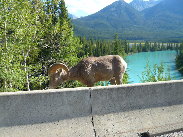
Bow Valley Parkway: Instead of taking the Hwy 1 back to our hotel, we
drove on Bow valley parkway which parallels Hwy 1 between Lake Louise
and Banff townsite. There are many viewpoints on the parkway, but the
most interesting thing we saw were a herd of bighorn sheep which were
grazing by the road.
Chiranjeeb
 |
| First Vermilion Lake at Sunrise |
Mt Rundle from the Vermilion lakes just outside Banff townsite.
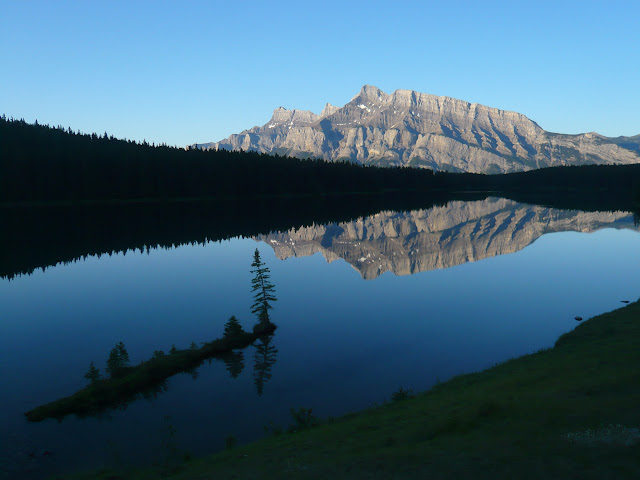 |
| Mount Rundle Reflected on Two Jack Lake |
Unfortunately, the morning light was not very good on Mt Rundle, and I
got some more interesting pictures at Two Jack Lake instead.
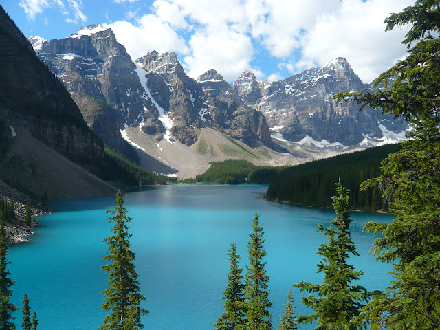 |
| Moraine Lake |
one of the most beautiful lakes in the Rockies with intense blue water
and beautiful valley of the Ten Peaks rising behind it. There were
beautiful red canoes paddling on the lake which added more contrast to
the scene. After the lake, we decided to take a hike to Larch Valley.
All the hikes around Moraine Lake required hikers to travel in groups
of four to protec against grizzly bears. We fell in with a couple and
started, but the thin air at this high altitude (6000+ ft) and
steepness of the trail stopped us after a bit. We decided to drive to
lake Louise instead.
 |
| Lake Louise |
beautiful hotel right next to it. There was a wedding going on at the
hotel at the lake shore.
 |
| lake Agnes |
We started on the lake Agnes trail (6.8 km
round trip, 285 m gain) and were at the lake in an hour. The lake is
set in a cirque surrounded by snow covered peaks and in the midst of
it all, there is a tea house serving many kinds of exotic tea. The
tea house is clearly very popular with the hikers as well as the horse
back riders. We had our lunch on the lake shore, turned back and were
back at the trail head soon. From the trail, the intermittent view of
Lake Louise was awesome.
 |
| Big Horn Sheep on Bow Valley Parkway |
drove on Bow valley parkway which parallels Hwy 1 between Lake Louise
and Banff townsite. There are many viewpoints on the parkway, but the
most interesting thing we saw were a herd of bighorn sheep which were
grazing by the road.
Chiranjeeb
Canadian Rockies Trip: Day 2 (Kootenay NP and Banff)
Saturday: July 24th
The day's plan was to drive to Kootenay national park and then enter Banff and finally
by evening reach our hotel at Canmore. After free breakfast at Super 8
we started out around 8:30. Within an hour we crossed the border with
minimum delay. After that it was a long drive to our next
destination: Radium Hot Springs, BC which is the gateway town to
Kootenay National Park. On the way, the scenery was becoming more and
more promising with the beautiful Kootenay river and Columbia lake
(origin of the Columnbia river) surrounded by steep mountains. The
lake and the river were tinged green with glacial flour. At Radium,
we stopped at the National Park visitor center and picked up
brochures/maps for the park. We bought our year long Candian national
park pass at the park gate for $136 which was quite steep compared to
the US park pass ($80). This was going to be a recurrent pattern
everywhere: the Candian park system appears to be significantly more
costly than the American system. However, the Canadian parks have
more winter facilities than the American ones.
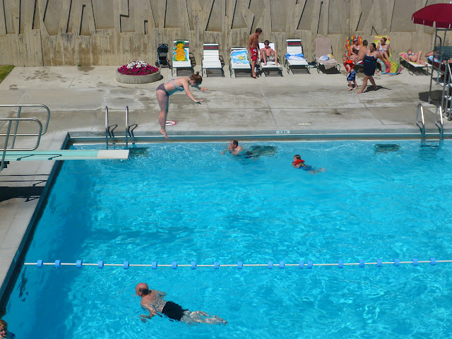
Radium Hot Springs: The hot springs at Kootenay are the key
attraction for the park, but they did not look much different from a
regular swimming pool. The hot water is piped from the springs to a
pool where you can go in. Lot of people frolicking in the pool, but
since we did not have any swim suits, we did not go into the water.
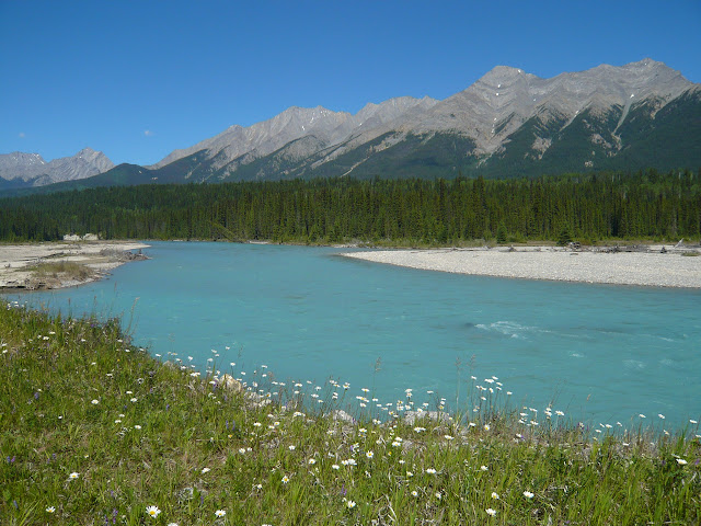
Kootenay River: The main road (Route 93) runs through the Kootenay
valley along the river. It is fed by glaciers which brings in finely
ground rock powder in the water. The suspended rock flour gives the
water a beautiful opaque green hue which is intensfied under mid day
sunlight. Most of the lakes and rivers in the Canadian rockies have
this beautful color. The valley was idyllic with beautiful mountains,
greeen trees and daisies blooming by the river.
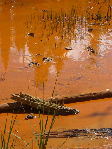
Paint Pots: The paint pots are actually pools where iron-rich
underground springs come out of the ground and stain the soil with
deep orange and ochre colors. It appears that the soil was used by
Indian tribes for body paint and were used by the white men for ochre
pigments. To us, the soil looked very much like any red soil from
Assam (especially the red soil around Jorabat) and we were not
particularly impressed. Nandana labelled the pools as "gela pukhuri".
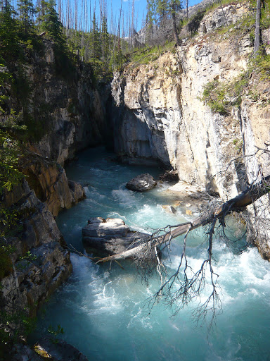
Marble Canyon: This is a beautiful slot canyon carved by the
Tokumn creek from white dolomitic rock. The trail crosses the
stream repeatedly and gives a good view into the canyon which is
approximately 150 feet deep at points and only 10 feet wide. The
river enters the canyon with a deep and powerful waterfall. In the
coming days, we saw other examples of this kind of canyons. Mt
Rainier also has a slot canyon like this, but not as beautiful or
deep. The southwest (Arizona and Utah) also has slot canyons, but
those are mostly dry most of the year.
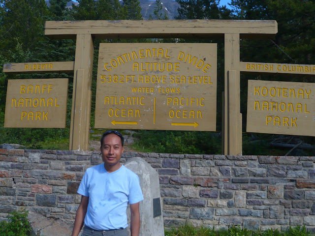
Continental Divide: The road crosses over from Kootenay to Banff
national parks over Vermilion pass. This pass divides Kootenay from
Banff, British Columbia from Alberta and finally the Pacific watershed
from the Atlantic watershed. Water from the east side of the pass
flows into Atlantic ocean while the water on the west side flows into
the Pacific ocean. The contnental divide is the demarcation line
between these two watersheds and runs along the spine of the Rocky
mountains.
We drove into Banff, took a few pictures in the Castle Junction and
drove into Canmore for our hotel (Grande Rockies Resort). It was a
very good deal for the money: a one bedroom suite with full kitchen
(granite counter tops!), two flat screen TVs and a shower which is
more complicated than Windows 7.
Chiranjeeb
The day's plan was to drive to Kootenay national park and then enter Banff and finally
by evening reach our hotel at Canmore. After free breakfast at Super 8
we started out around 8:30. Within an hour we crossed the border with
minimum delay. After that it was a long drive to our next
destination: Radium Hot Springs, BC which is the gateway town to
Kootenay National Park. On the way, the scenery was becoming more and
more promising with the beautiful Kootenay river and Columbia lake
(origin of the Columnbia river) surrounded by steep mountains. The
lake and the river were tinged green with glacial flour. At Radium,
we stopped at the National Park visitor center and picked up
brochures/maps for the park. We bought our year long Candian national
park pass at the park gate for $136 which was quite steep compared to
the US park pass ($80). This was going to be a recurrent pattern
everywhere: the Candian park system appears to be significantly more
costly than the American system. However, the Canadian parks have
more winter facilities than the American ones.
 |
| Radium Hot Springs |
attraction for the park, but they did not look much different from a
regular swimming pool. The hot water is piped from the springs to a
pool where you can go in. Lot of people frolicking in the pool, but
since we did not have any swim suits, we did not go into the water.
 |
| Kootenay River |
valley along the river. It is fed by glaciers which brings in finely
ground rock powder in the water. The suspended rock flour gives the
water a beautiful opaque green hue which is intensfied under mid day
sunlight. Most of the lakes and rivers in the Canadian rockies have
this beautful color. The valley was idyllic with beautiful mountains,
greeen trees and daisies blooming by the river.
 |
| Paint Pots |
underground springs come out of the ground and stain the soil with
deep orange and ochre colors. It appears that the soil was used by
Indian tribes for body paint and were used by the white men for ochre
pigments. To us, the soil looked very much like any red soil from
Assam (especially the red soil around Jorabat) and we were not
particularly impressed. Nandana labelled the pools as "gela pukhuri".
 |
| Marble Canyon |
Marble Canyon: This is a beautiful slot canyon carved by the
Tokumn creek from white dolomitic rock. The trail crosses the
stream repeatedly and gives a good view into the canyon which is
approximately 150 feet deep at points and only 10 feet wide. The
river enters the canyon with a deep and powerful waterfall. In the
coming days, we saw other examples of this kind of canyons. Mt
Rainier also has a slot canyon like this, but not as beautiful or
deep. The southwest (Arizona and Utah) also has slot canyons, but
those are mostly dry most of the year.
 |
| Vermilion Pass and Continental Divide |
national parks over Vermilion pass. This pass divides Kootenay from
Banff, British Columbia from Alberta and finally the Pacific watershed
from the Atlantic watershed. Water from the east side of the pass
flows into Atlantic ocean while the water on the west side flows into
the Pacific ocean. The contnental divide is the demarcation line
between these two watersheds and runs along the spine of the Rocky
mountains.
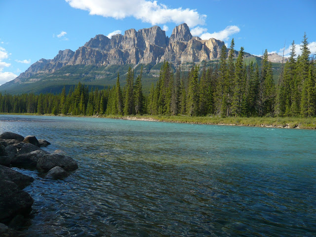 |
| Castle Mountain and Bow River |
drove into Canmore for our hotel (Grande Rockies Resort). It was a
very good deal for the money: a one bedroom suite with full kitchen
(granite counter tops!), two flat screen TVs and a shower which is
more complicated than Windows 7.
Chiranjeeb
Canadian Rockies Trip: Day 1
This is a belated trip report of our trip to the Canadian Rockies.
Friday: July 23rd
We started out of Seattle at exactly 4PM. The plan was to take I-90
to Coeur d'Alene and then turn north to Canada border via Bonners
Ferry. I got out of work a little bit early while Nandana packed the
car. The traffic was light out of Seattle and we made good time until
Issaquah. That's when we realized that we forgot our USB cable for
the digital camera: a frantic search on iPhone revealed that the
closest Radio Shack was on the next exit. Radio Shack did not have
the right cable, but instead we got a 4GB SD card which should hold
the photos we were likely to shoot. It was smooth sailing after that
and we did not stop until Spokane to get gas. Saranga and Gitashree
were also en route to Yellowstone and we had hourly update from them
on their progress. They were about 30 mins ahead of us on the way and
we parted ways at Coeur d'Alene where they continued on I-90 to
Missoula, MT. We had not booked any motel on the way for that night.
Searching for hotels on the GPS and calling them finally yielded a
Super 8 at Ponderay, ID. We would have preferred to go further, but
there was nothing available in Bonners Ferry and the next significant
town inside Canada was too far away.
Chiranjeeb
Tuesday, August 10, 2010
California trip: a few observations
While Chiranjeeb has taken up the responsibility of writing the day to day account of the trip (which I hope he will finish writing ..some day !) I just thought of sharing a few random observations from the trip.
1. Road trip is a good experience. When you fly, You are lifted from one place and dropped in another. But the gradual change climate, terrain etc can be experienced only on a road trip.

2. San Francisco is a place which I found totally flooded with tourists. In all other places you do see tourists, but there will be local people around too. But somehow in San Francisco I saw only tourists, with maps & guidebooks in their hands. As if local people have given up their city to the tourists, and decided to lock themselves up inside their houses. Well, this observation may be due to the fact that I stayed in downtown San Francisco, but I found it really striking about this city.
3. The pier 39 in San Francisco is pure hype. If you stay in the city , you can go there and hang out if you want. But for a tourists they don’t really offer anything…just shops. Those Sea
lions are interesting..but the place stinks so much, you can’t think of spending more than few minutes there ! :)
4. Lombard street is fun. But I really wonder how the people living at that neighborhood manage..with all the tourists 24/7 !

5. UC Berkeley surprised me a bit. I was expecting a more traditional looking campus. But the most interesting thing I heard about UCB is that, it seems a they have few parking spots reserved for Nobel Laureates !! I really wanted check it out..but we were pressed for time. Anyway, next time will try to find that out, and in case I spot any car parked there..will definitely hang around !:)
6. Golden gate bridge is best thing San Francisco has to offer. But with all the fog, you have to be really lucky to get a full view of the bridge…particularly during summer. Bdw, You get the best view from the Marin county.

7. Stanford campus is pretty impressive, with all the Palm drive and all.
8. Santa Barbara is the place, I liked the most. It’s small cute town with everything built in Spanish style. It’s a place where all the rich people of California retire, and you come across that laid back atmosphere everywhere…people sitting leisurely in a roadside coffee shop,sipping coffee & chatting. Other than the beautiful beaches, the town offers nothing very touristy thing to do and that’s the best thing about it. This is a place where I
would love to go back again for a relaxed vacation.

9. Other than all the BTDTs in L.A, I think one very interesting place one should visit is the Getty Center. (It has no entrance fee, but has a parking fee for $ 15). The place is extremely well maintained. For those who are interested in Art , sculpture, Photography etc, the center has lot to offer. All you need is time..you can’t rush through them.
10. Oh bdw,if you go to L.A, try to stay at Westin.. I mean that’s where you might get it at an affordable price, like we did. They claim to have the best beds among all the luxury hotels which they call ‘Heavenly beds’, and they are indeed heavenly! :)
11. It seems I experienced one of the rarest things in Yosemite..rain !! and it was a real bummer. After camping there for the night, we had to abandon our plans for hikes and climbs for the next day and get out of he park as soon as possible. Yosemite otherwise is nice national park, you can see lot of stuff ..mountain, lakes , beautiful meadows within a short distance. I think that makes the park so popular.
Nandana
1. Road trip is a good experience. When you fly, You are lifted from one place and dropped in another. But the gradual change climate, terrain etc can be experienced only on a road trip.

2. San Francisco is a place which I found totally flooded with tourists. In all other places you do see tourists, but there will be local people around too. But somehow in San Francisco I saw only tourists, with maps & guidebooks in their hands. As if local people have given up their city to the tourists, and decided to lock themselves up inside their houses. Well, this observation may be due to the fact that I stayed in downtown San Francisco, but I found it really striking about this city.
3. The pier 39 in San Francisco is pure hype. If you stay in the city , you can go there and hang out if you want. But for a tourists they don’t really offer anything…just shops. Those Sea
lions are interesting..but the place stinks so much, you can’t think of spending more than few minutes there ! :)
4. Lombard street is fun. But I really wonder how the people living at that neighborhood manage..with all the tourists 24/7 !

5. UC Berkeley surprised me a bit. I was expecting a more traditional looking campus. But the most interesting thing I heard about UCB is that, it seems a they have few parking spots reserved for Nobel Laureates !! I really wanted check it out..but we were pressed for time. Anyway, next time will try to find that out, and in case I spot any car parked there..will definitely hang around !:)
6. Golden gate bridge is best thing San Francisco has to offer. But with all the fog, you have to be really lucky to get a full view of the bridge…particularly during summer. Bdw, You get the best view from the Marin county.

8. Santa Barbara is the place, I liked the most. It’s small cute town with everything built in Spanish style. It’s a place where all the rich people of California retire, and you come across that laid back atmosphere everywhere…people sitting leisurely in a roadside coffee shop,sipping coffee & chatting. Other than the beautiful beaches, the town offers nothing very touristy thing to do and that’s the best thing about it. This is a place where I
would love to go back again for a relaxed vacation.

9. Other than all the BTDTs in L.A, I think one very interesting place one should visit is the Getty Center. (It has no entrance fee, but has a parking fee for $ 15). The place is extremely well maintained. For those who are interested in Art , sculpture, Photography etc, the center has lot to offer. All you need is time..you can’t rush through them.
10. Oh bdw,if you go to L.A, try to stay at Westin.. I mean that’s where you might get it at an affordable price, like we did. They claim to have the best beds among all the luxury hotels which they call ‘Heavenly beds’, and they are indeed heavenly! :)
11. It seems I experienced one of the rarest things in Yosemite..rain !! and it was a real bummer. After camping there for the night, we had to abandon our plans for hikes and climbs for the next day and get out of he park as soon as possible. Yosemite otherwise is nice national park, you can see lot of stuff ..mountain, lakes , beautiful meadows within a short distance. I think that makes the park so popular.
Nandana
Friday, August 28, 2009
Road Trip to California: Day 1
avelWe are back from the road trip. Now that the road trip is over, we must publish a travelogue on our blog. So in the next few posts we shall cover each and every day of the trip.
Day 1 was Friday, Aug 14th. Nandana picked me up at work around 4:30PM. For our camping trip we needed the headlamp which I had loaned to Ajit ---so we drove around to his office to pick it up. Ajit's comment when he saw Nandana driving: "You are doing a great service by keeping dangerous drivers like him away from the road". He never did care much for my driving skills.
The drive was monotonous: we switched drivers every couple of hours. It got dark around Portland and after that there was just a succession of signs, exits and towns: Wilsonville, Salem, Eugene, Roseburg.... Driving in night one is hardly aware of progress ---the landcsape around is a mass of darkness with the highway two rivers of lights: one red and slow, the other white and fast. We were planning to push on to Medford to spend the night, but after Roseburg tiredness took over. We decided to stop at Grants Pass ---we saw a sign for Motel6, took the exit and called it a night after a quick check-in.
Chiranjeeb
Friday, August 14, 2009
Road trip to California
We are starting our trip to California today. I have just finished loading the car and am totally amazed at the amount of things we are carrying !! Of course, I am being quite liberal with packing as we are taking the car. But our plan to camp & climb in Yosemite has added a huge load to the luggage. Till yesterday we could not find a single campsite in Yosemite.. all of them were booked. But then Chiranjeeb got this bright idea from one of his more enterprising friends that, the trick lies in refreshing the park website again and again..! at some point you are going to get a campsite ... people keep canceling their booking for various reasons. And that actually happened ! ( you can try that, it works). So, now we have all these extra things to carry..the tent, sleeping bags, cooking equipments, climbing equipments ..! No wonder we have our car full.
Now, I just hope that I don't leave behind something crucial..like the GPS. This reminds me of my old habit of leaving behind my wrist watch everywhere I go. Then finally my brother gave me a seemingly ordinary but very useful tip..'always keep it next to something without which you just can't move, like your car key'. that actually helped... I have not lost a single watch after that.
Anyway, we plan to hit four places San Francisco , Santa Barbara, LA and Yosemite. Planning to take it slow this time. But then, I have my own must-dos..like shopping at the North Face outlet store in Berkeley ! :)
Nandana
Subscribe to:
Comments (Atom)